STORM WATCH: Nor’easter brings rain, snow & wind; state of emergency declared for parts of the state
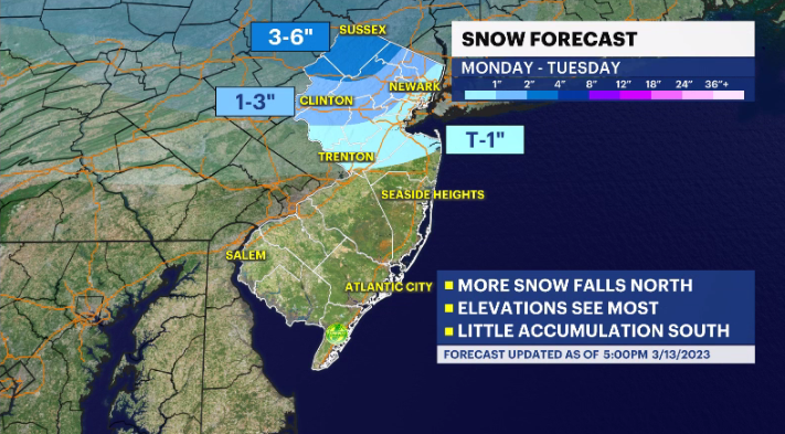
Storm Watch Team Meteorologist Dave Curren says that while some areas of the state could see some snow, this storm will not be a snow event for the Garden State.
•
Mar 13, 2023, 11:13 AM
•
Updated 544 days ago
Share:
More Stories
2:09

Saturn to be visible this weekend, with best viewing on Sunday
yesterday1:39

Why has hurricane season quieted down?
2ds ago
LIVE BLOG: News 12 weather updates
10ds ago1:04

Cooler temperature trend into start of meteorological fall
10ds ago1:34

Greenwood Lake leaders warn visitors to use common sense in the heat
10ds ago2:26

Heat & humidity strengthen, storm chances weaken, to bring a pleasant end to week
11ds ago2:09
Saturn to be visible this weekend, with best viewing on Sunday
yesterday1:39
Why has hurricane season quieted down?
2ds agoLIVE BLOG: News 12 weather updates
10ds ago1:04
Cooler temperature trend into start of meteorological fall
10ds ago1:34
Greenwood Lake leaders warn visitors to use common sense in the heat
10ds ago2:26
Heat & humidity strengthen, storm chances weaken, to bring a pleasant end to week
11ds agoProgramming Note: News 12 New Jersey will be LIVE Tuesday at 4:30 a.m. showing you the forecast outlook and conditions on the roads. Stay safe.
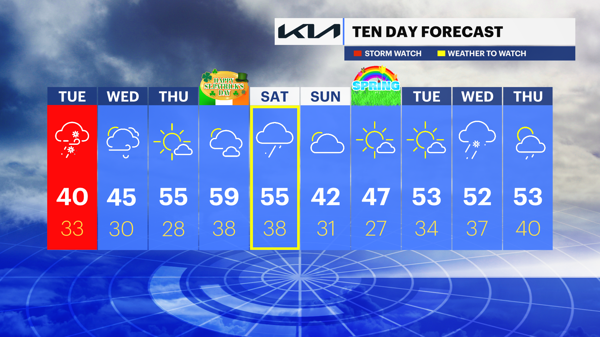
A nor’easter storm will make New Jersey cold, dreary and wet for the next few days.
A state of emergency has been issued for Bergen, Morris, Passaic, Sussex and Warren counties.
Storm Watch Team Meteorologist Dave Curren says that while some areas of the state could see some snow, this storm will not be a snow event for the Garden State.
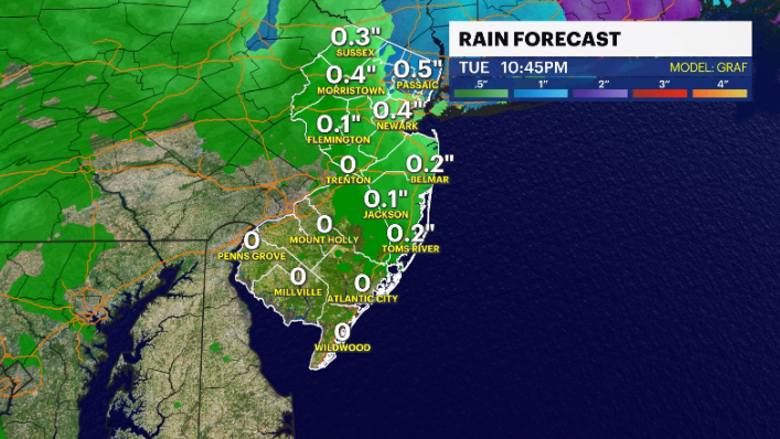
WHAT’S NEXT: Rain and wind will be the major impact of this storm. Curren says the rainy conditions are expected to last into Wednesday. He says there will be a 36-48 hour stretch of rainy and breezy weather across most of the state.
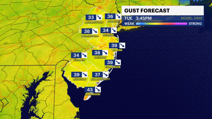
The roads will be wet and there is the potential for large puddles to form. Drivers should use caution. Snow is possible in areas of the state in higher elevations. Coastal flooding is possible, but Curren says it is unlikely.
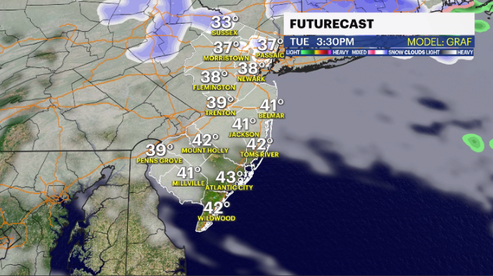
TUESDAY: Rain, wind and some snow. Daytime highs around 40 degrees. Overnight lows around 33
WEDNESDAY: Clouds and wind. Rain moves out. Daytime highs around 45. Overnight lows around 30.
THURSDAY: Mostly sunny skies return. Temperatures mild in the mid-50s. Overnight lows around 28.
FRIDAY: Mostly cloudy with temperatures in the upper-50s. Overnight lows around 38.
More from News 12
1:39
Why has hurricane season quieted down?
1:53

Record rainfall: The deadly flooding by the numbers
1:43

Tri-state drought monitor for Aug. 14, 2024
0:28

Close call: Tree branch falls near News 12 crew covering Debby's impact in Rockland
1:09

Heavy rain from Debby spares flooding on Rockland County's Route 59
1:24
