Temperatures soar into the weekend in Brooklyn
Mostly clear and quiet conditions for the overnight. Temperatures stay balmy, in the higher 60s and lower 70s.
Share:
More Stories
1:59

Temps rise and humidity builds for Thursday, chances for rain increase headed into the weekend
8h ago1:16
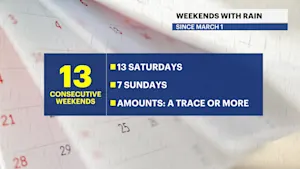
Streak of weekends with rain set to continue for lower Hudson Valley
yesterday1:59

Sunny and clear Monday in the Hudson Valley before temps soar later this week
3ds ago1:59

Memorial Day weekend ends with beautiful evening in the Hudson Valley
9ds ago
News 12 weather blog
19ds ago1:59

Sunny and pleasant Monday in Hudson Valley; more rain chances this week
24ds ago1:59
Temps rise and humidity builds for Thursday, chances for rain increase headed into the weekend
8h ago1:16
Streak of weekends with rain set to continue for lower Hudson Valley
yesterday1:59
Sunny and clear Monday in the Hudson Valley before temps soar later this week
3ds ago1:59
Memorial Day weekend ends with beautiful evening in the Hudson Valley
9ds agoNews 12 weather blog
19ds ago1:59
Sunny and pleasant Monday in Hudson Valley; more rain chances this week
24ds agoSmoke should begin to improve as we head into the overnight and into early Thursday.
We are still dealing with elevated levels of ozone leading to the Air Quality Alert the National Weather Service has in place until 11 p.m.
Mostly clear and quiet conditions for the overnight. Temperatures stay balmy, in the higher 60s and lower 70s.
We will see major heat for Thursday! The potential for our first 90-degree day.

Record highs for our region are 99 degrees, so not record breaking but definitely notable. We stay warmer until Saturday, where we will cool to the 70s and remain there for much of the upcoming week.
Rain chances for Friday and Saturday, with the potential for thunderstorms as well.
FORECAST:
THURSDAY: Mostly sunny and slightly humid. Highs in the high 80s and with enough sunshine, the low 90s potentially. Lows in the low 70s. Some patchy fog is possible.

FRIDAY: Highs in the middle to higher 80s, lows in the higher 60s. Shower chances and late evening shower and thunderstorm chances as well.
THE WEEKEND: Saturday will see cooler temps, but also clouds, showers, and thunderstorm chances. More comfortable temperatures in the middle 70s.
We stay in the 70s for Sunday, which will (once again) be the nicer day of the weekend. Mostly sunny and drier, a stray shower is possible, however.
NEXT WEEK: Temperatures remain in the 70-degree range, a cooler more pleasant place to be. Rain chances are with us for early parts of next week as well.

More from News 12
1:59
Temps rise and humidity builds for Thursday, chances for rain increase headed into the weekend
1:59
Sunny and clear Monday in the Hudson Valley before temps soar later this week
1:59
Memorial Day weekend ends with beautiful evening in the Hudson Valley
News 12 weather blog
1:59
Sunny and pleasant Monday in Hudson Valley; more rain chances this week
1:59
