Another cool, cloudy and damp day; warmer weather returns by midweek for Brooklyn
For tonight, expect mostly cloudy and cool temperatures with lows near 62 degrees.
Share:
More Stories
1:46

Cool and damp to start the week; Multiple 90 degree days are in sight
3h ago1:46

Stormy pattern this week in the Hudson Valley
15h ago1:46

Wet start to the week in the Hudson Valley; sunshine returns midweek
7ds ago1:16
Streak of weekends with rain set to continue for lower Hudson Valley
12ds ago1:46

Sunny and clear Monday in the Hudson Valley before temps soar later this week
14ds ago1:46

Memorial Day weekend ends with beautiful evening in the Hudson Valley
20ds ago1:46
Cool and damp to start the week; Multiple 90 degree days are in sight
3h ago1:46
Stormy pattern this week in the Hudson Valley
15h ago1:46
Wet start to the week in the Hudson Valley; sunshine returns midweek
7ds ago1:16
Streak of weekends with rain set to continue for lower Hudson Valley
12ds ago1:46
Sunny and clear Monday in the Hudson Valley before temps soar later this week
14ds ago1:46
Memorial Day weekend ends with beautiful evening in the Hudson Valley
20ds agoHere’s what you need to know:
- It's cool and cloudy this morning. Temperatures are in the upper 50s to low 60s.
- Today will be cloudy with patchy drizzle and slightly milder temperatures. Highs will be in the upper 60s.
- A persistent easterly wind will bring a blanket of clouds to our area through tomorrow with below normal temperatures in the 60s and low 70s.
- It gets warmer, humid with a chance of storms on Wednesday and Thursday. There's a chance of showers and storms for the Wednesday morning commute and Wednesday evening before sunset. Temperatures will be climbing into the 80s, near 90 degrees.
- A strong cold front will bring a chance of strong thunderstorms on Thursday afternoon and evening. Stay tuned for updates on the timing and potential impacts.
- The Summer Solstice officially begins on Friday at 10:41 p.m. Friday will be bright, warm and less humid. Highs will be in the low 80s.
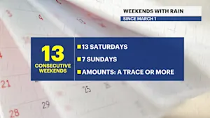
- We've had 8 consistent weekends with measurable rainfall since late April. We might be finally breaking our rainy weekend streak this weekend with sunshine and warmer temperatures in the mid to upper 80s.
- There's a potential for an extended period of extreme heat and humidity early next week. Stay tuned for updates!
Today: Cloudy, cooler and damp. Highs near 68.


Tonight: Mostly cloudy and cool. Lows near 62.

Tuesday: Cloudy, below seasonable with sprinkles. Highs near 70. Lows near 64.

Wednesday: Chance of AM stray t-storm. Partly sunny, warm and muggy. Highs near 83. Lows near 72.

Thursday (Juneteenth): Sunny, high heat and humidity. Chance of PM spotty t-storms. Highs near 89. Lows near 70.
More from News 12
1:46
Cool and damp to start the week; Multiple 90 degree days are in sight
1:46
Stormy pattern this week in the Hudson Valley
1:46
Wet start to the week in the Hudson Valley; sunshine returns midweek
1:46
Sunny and clear Monday in the Hudson Valley before temps soar later this week
1:46
Memorial Day weekend ends with beautiful evening in the Hudson Valley
