Blizzard or Bust? The chances of a major snowstorm this weekend
There is a lot of uncertainty about the storm track at this early stage, typical for any storm that is five or more days away. In this particular forecast, there could be a "phase" between two pieces of energy that would create a blockbuster storm on Saturday.
More Stories


A storm is likely to form and move toward the East Coast this weekend.
Will it be a big storm that directly hits the five boroughs or a small storm that misses the city?
There is a lot of uncertainty about the storm track at this early stage, typical for any storm that is five or more days away. In this particular forecast, there could be a "phase" between two pieces of energy that would create a blockbuster storm on Saturday.
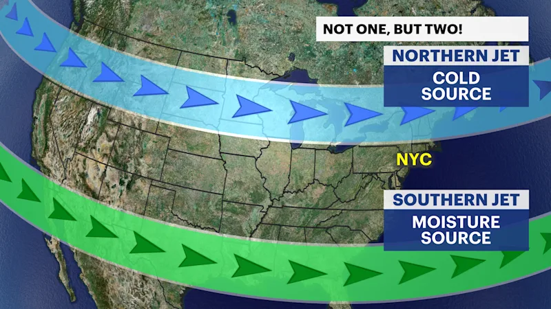
Taking a closer look at the setup, the jet stream contains important clues that could determine the outcome of the storm.
While many think of the jet stream as one large "river" of air, there are two jet streams across America that steer storms, the "southern" and "northern" jet streams.
The southern (subtropical) jet contains the moisture as it is usually located closer to the Caribbean. The northern (polar) jet contains the cold air as it is usually located closer to the North Pole. Since the atmosphere and jet streams do not operate in straight lines, these jet streams can bend and dip, and sometimes combine, known as a "phase."
When the northern and southern jet streams phase, with a piece of storm energy in each branch, that is a recipe for a significant storm. The GFS model does just that this weekend, combining the northern and southern pieces of energy to create a potential blizzard on Saturday. That is only one scenario.
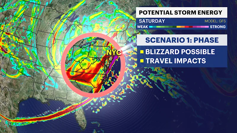
Instead of the GFS model, the European model keeps the two pieces of energy separate without ever combining them. If they stay separate, that means no phase, and potentially no snow at all. The phase is the key to Saturday's storm!

When will we know which scenario is most likely? Some of the energy is still located over the Pacific Ocean where there are no instruments to take observations and measurements.
Once all of the potential storm energy reaches land, much more data will be available to make a definitive forecast. That is expected to happen on Wednesday.
Between now and then - as well as through the weekend - check back with News 12 and follow me on social media on Instagram, X, Facebook at @AWxNYC.


