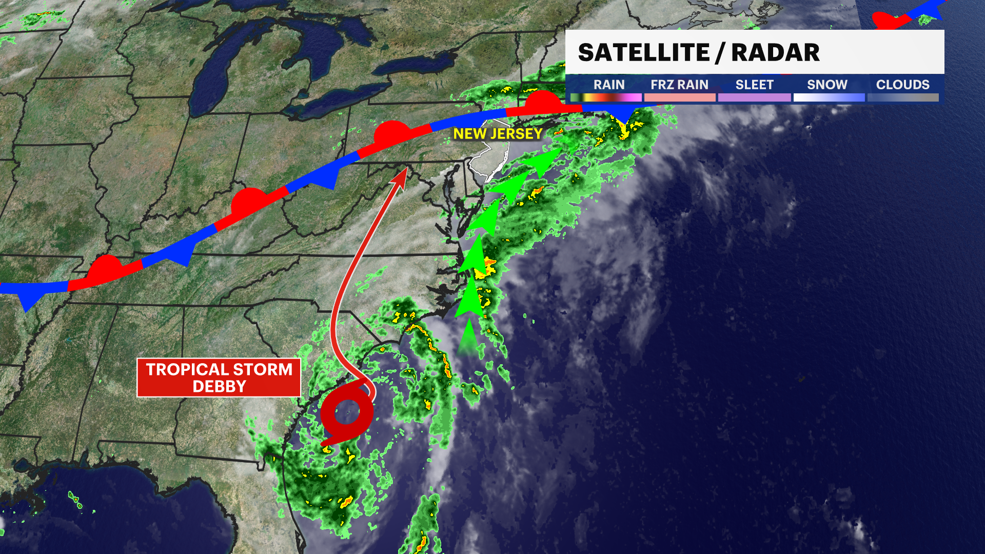
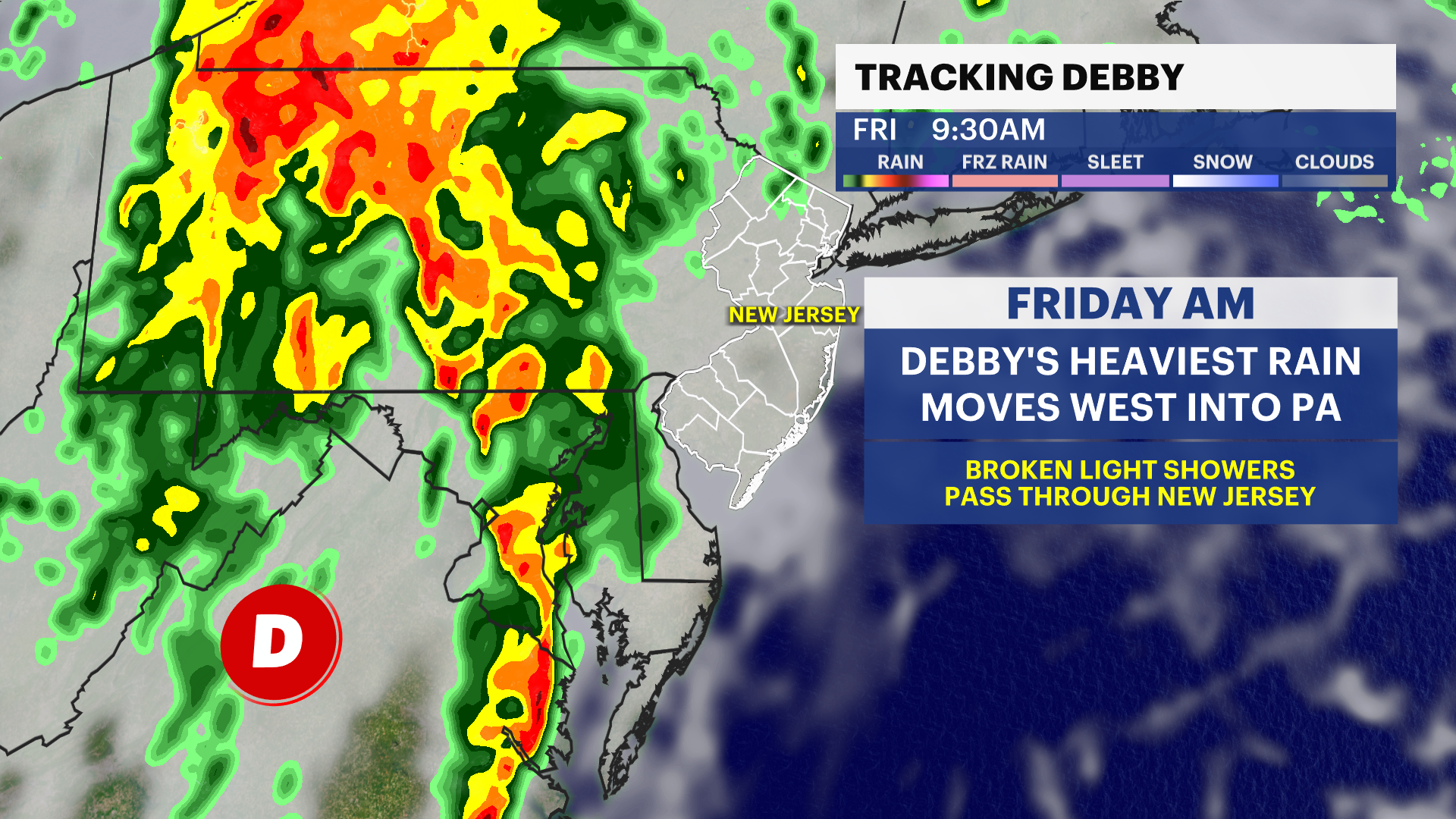
Debby tracks west of New Jersey, impacts still expected Friday afternoon and evening
All of New Jersey should plan for the potential for flooding rain on Friday afternoon and evening as a result of Debby's moisture.
Share:
More Stories
1:42

Comfortable temperatures ahead for the weekend
4h ago1:38

Lightning strike ignites garage fire in Yonkers
6ds ago
News 12 weather blog
6ds ago2:16

Possible heat wave looms this week in the Hudson Valley
33ds ago1:42

Warm and pleasant week ahead in the Hudson Valley
40ds ago1:42

Rain is on the way out as we finish out July in the Hudson Valley
43ds ago1:42

Comfortable temperatures ahead for the weekend
4h ago1:38

Lightning strike ignites garage fire in Yonkers
6ds ago
News 12 weather blog
6ds ago2:16

Possible heat wave looms this week in the Hudson Valley
33ds ago1:42

Warm and pleasant week ahead in the Hudson Valley
40ds ago1:42

Rain is on the way out as we finish out July in the Hudson Valley
43ds agoWHAT: Tropical Storm Debby's moisture is expected to pass to the west of New Jersey, producing rounds of downpours and flooding that pass-through New Jersey for the afternoon and evening. Currently, rainfall can exceed 1-3" across New Jersey for the afternoon batch of rain, but the heaviest of the rain stays over Pennsylvania through the day. Debby's center is like to pass by west and north of New Jersey sometime on Friday midday, but the backside of the storm is drier and breezy. Rapid improvement is expected overnight Friday into Saturday morning with a great weekend in the forecast. Thunderstorms that form on Friday afternoon have the likelihood of producing widespread flash flooding and strong/damaging wind gusts.

FORECAST: New Jersey's weather center
WHERE: All of New Jersey should plan for the potential for flooding rain on Friday afternoon and evening as a result of Debby's moisture. Thunderstorms will roll in from the west/northwest and cross the state through the evening. It clears rapidly afterward from west to east.

WHEN: Scattered rain showers persist today and tomorrow ahead of Debby's rain as the weather front responsible for steering Debby west of New Jersey continues to sweat out showers locally. Debby's downpours and thunderstorms are expected after 3 p.m. on Friday with rapid improvement from west to east on Saturday early morning as a front clears the moisture. Saturday will be breezy all day with lower humidity, sunshine, and warm temperatures.

This forecast is increasing in certainty and there may be minor adjustments to the storm's track as it moves inland. If this storm moves slightly more eastward, it will bring steadier showers on Friday morning without changing the risk for afternoon storms. This slight eastward shift would increase rainfall totals slightly. This scenario is decreasing in likelihood, but still on the table for now. We are certain the air clears rapidly after the batch of Friday evening rain as another weather front kicks the moisture away, replacing it with clear air and low humidity.

More from News 12
2:14

Suspect in Charlie Kirk killing became more political, opposed activist’s views, authorities say
1:41

Freshman makes history as first woman to play men's baseball at Monroe University
1:29

Could Indian Point nuclear power plant Be restarted?
1:42

Comfortable temperatures ahead for the weekend
1:55

'Man in the Red Bandana' up for Medal of Freedom and Congressional Gold Medal for his heroism on 9/11
1:39
