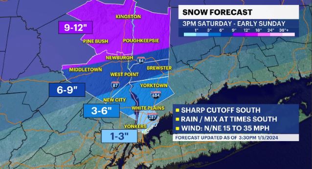
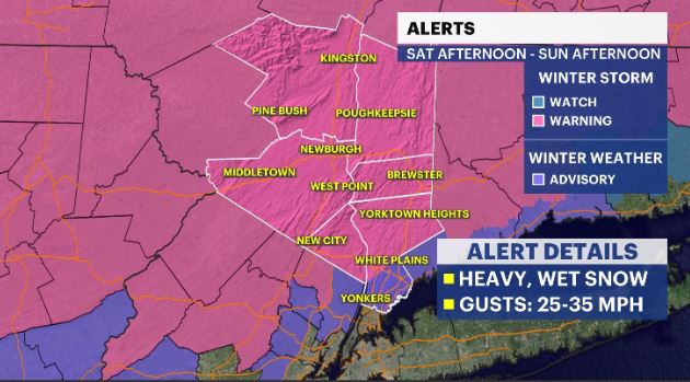
STORM WATCH: Winter storm to hit Hudson Valley Saturday afternoon; 6 to 12 inches possible in some areas
A winter storm warning will be in effect from 4 p.m. Saturday to 6 p.m. Sunday for parts of Northern Westchester, Orange, Putnam and Rockland counties.
More Stories


A winter storm warning will be in effect from 4 p.m. Saturday to 6 p.m. Sunday for parts of Northern Westchester, Orange, Putnam and Rockland counties.
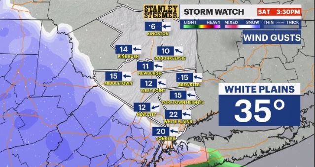
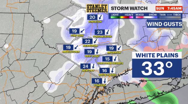
News 12 Storm Watch Team Meteorologist Addison Green says a winter storm will arrive in the Hudson Valley Saturday afternoon, bringing between 6 to 12 inches of snow in some areas.
WHAT YOU NEED TO KNOW:
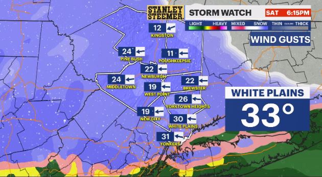
- Heavy, wet snow will be an issue with this approaching coastal storm, especially for areas north and west of I-87 and I-84.
- The storm moves in Saturday afternoon, with precipitation falling initially as a wintry mix for most, and rain closer to the city.
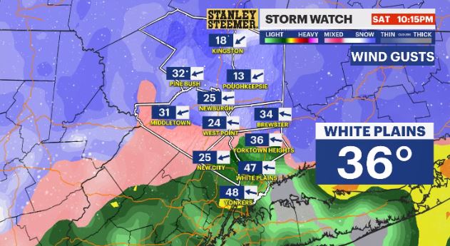
- Higher snowfall rates are anticipated for overnight Saturday.
- Another system will come this way Tuesday into Wednesday, where that one is looking to have warmer temperatures so it will be mainly a rain event with gusty winds.
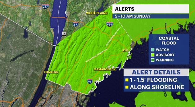
- That next system may cause flood concerns if it brings warmth and rain, and there is still fresh snow on the ground with snow melting.
FORECAST:
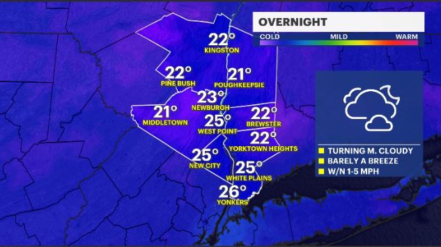
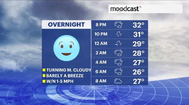
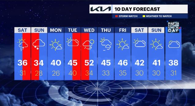
OVERNIGHT: Mostly cloudy with a light to calm wind. Lows in the low- to mid-20s.
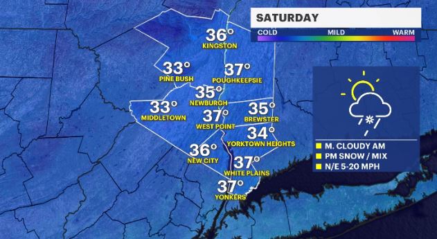
SATURDAY - STORM WATCH (P.M.): Mostly cloudy skies with a chance for rain/mix/snow showers to move in for the afternoon hours. Highs in the mid- to upper-30s. Lows in the upper-20s to low-30s.
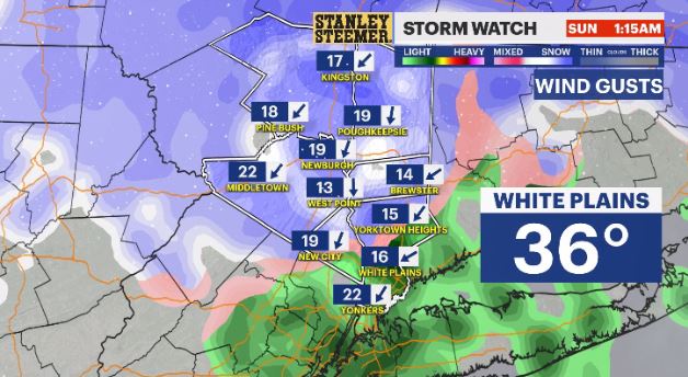
SUNDAY - STORM WATCH (A.M.): Potential for a wintry mix to all snow, wrapping up by midday, with breezy to windy conditions. Highs in the low- to mid-30s. Lows in the mid- to upper-20s.
MONDAY: Mostly sunny. Highs in the upper-30s to low-40s. Lows in the mid-20s.
TUESDAY - STORM WATCH (P.M.): Increasing cloud cover with a shower chance for second half of the day. Highs in the mid- to upper-40s. Lows in the upper- to mid-30s.
WEDNESDAY - STORM WATCH (A.M.): Mostly cloudy with rain through the first half of the day, then drier and breezy conditions. Highs in the mid- to upper-40s. Lows in the upper-20s to mid-30s.
THURSDAY: Partly cloudy with breezy winds at times. Highs in the low-40s. Lows in the upper-20s to low-30s.
FRIDAY: Mostly sunny to mostly cloudy with a late day shower chance. High in the mid-40s. Lows in the mid-30s.
SATURDAY: Cloudy with a chance for rain showers. High in the upper-30s low-40s. Lows in the upper-20s to low-30s.
SUNDAY: Mostly sunny. Highs in the upper-30s to low-40s. Lows in the upper-20s to low-30s.
MONDAY - MARTIN LUTHER KING JR. DAY: Mostly cloudy with a chance for snow showers. Highs in the mid- to upper-30s. Lows in the upper-20s to low-30s.
MORE:
25 tips to keep you safe during a winter storm
9 tips to prepare your vehicle for the frigid temperatures
These 20 tips will help you travel safely during winter storms
CAUTION! 9 tips to keep you safe on the road and at home during winter weather conditions


