HEAT ALERT: Hot and humid conditions stick around into the weekend; severe threat Saturday
Spotty storms tomorrow will usher in more comfortable summer weather starting Sunday.
More Stories


High levels of heat and humidity will continue to be an issue into Saturday, but the end is finally near.
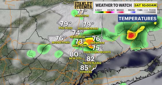
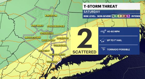
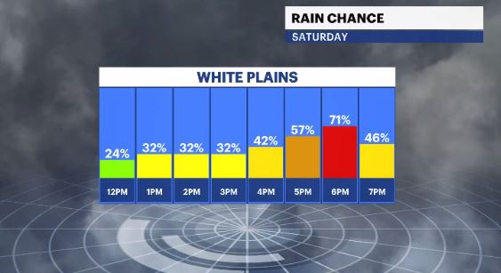
There is a threat of severe weather on Saturday as a cold front approaches the region. The threat for strong to severe storms is a 2 out of 5 on our threat scale. Rockland and Westchester counties are in that 2 level. To the north and west of I-84 & I-87 is a 1 out of 5 on our scale. The main threats are strong, damaging winds and small hail. The tornado threat is running low.
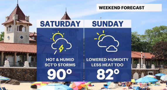
Much more pleasant weather is on the way, starting Sunday. Temps will cool down to, and hang around, the average high of 83. Humidity levels will fall from “it’s like a sauna out here” to “delightful!”
OVERNIGHT: Mostly cloudy, staying muggy with some passing showers by daybreak. Lows: upper-60s to upper-70s.
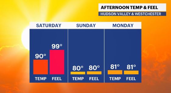
SATURDAY: Heat Alert/Weather To Watch - Partly cloudy with scattered storms. Some could be strong to severe Highs: Upper-80s to low-90s. Lows: Upper-60s to low-70s.
SUNDAY: A mix of sun & clouds, lowered levels of humidity and seasonable temps. Highs: Upper-70s to low-80s. Lows: Low-60s.
MONDAY: Partly cloudy with a scattered shower chance, mainly in the morning hours. Highs: Upper-70s to low-80s. Lows: Upper-50s to low-60s.
TUESDAY: Mostly sunny & pleasant. Highs: Upper-70s to low-80s. Lows: Upper-50s to low-60s.
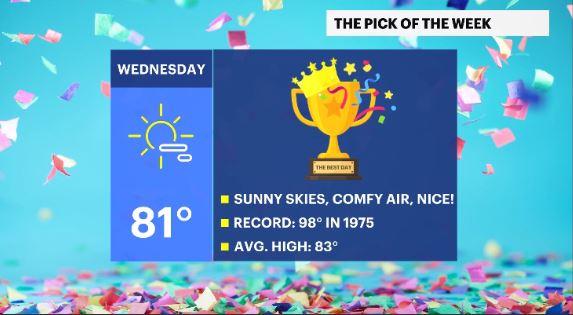
WEDNESDAY: *Pick of the week* - Mainly sunny and pleasant levels of humidity. Highs: Upper-70s to low-80s. Lows: Mid-60s.
THURSDAY: Partly cloudy to mostly cloudy with a PM rain/storm chance. Highs: Upper-70s to low-80s. Lows: Mid-60s.
NEXT FRIDAY: Partly cloudy with a scattered shower chance. Highs: Upper-70s to low-80s. Lows: Low-60s.