Weather to Watch: Warm Thursday with threat of thunderstorms in the Hudson Valley
Storm Watch Team Meteorologist Addison Green says a warm spring day lies ahead with a threat of thunderstorms.
Share:
More Stories
1:39

Why has hurricane season quieted down?
2ds ago1:53

Record rainfall: The deadly flooding by the numbers
19ds ago1:43

Tri-state drought monitor for Aug. 14, 2024
24ds ago0:28

Close call: Tree branch falls near News 12 crew covering Debby's impact in Rockland
29ds ago1:09

Heavy rain from Debby spares flooding on Rockland County's Route 59
29ds ago1:24

Major road closures in Yorktown after storm damages trees, power lines
29ds ago1:39
Why has hurricane season quieted down?
2ds ago1:53
Record rainfall: The deadly flooding by the numbers
19ds ago1:43
Tri-state drought monitor for Aug. 14, 2024
24ds ago0:28
Close call: Tree branch falls near News 12 crew covering Debby's impact in Rockland
29ds ago1:09
Heavy rain from Debby spares flooding on Rockland County's Route 59
29ds ago1:24
Major road closures in Yorktown after storm damages trees, power lines
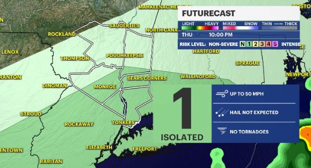
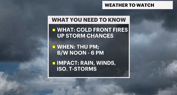
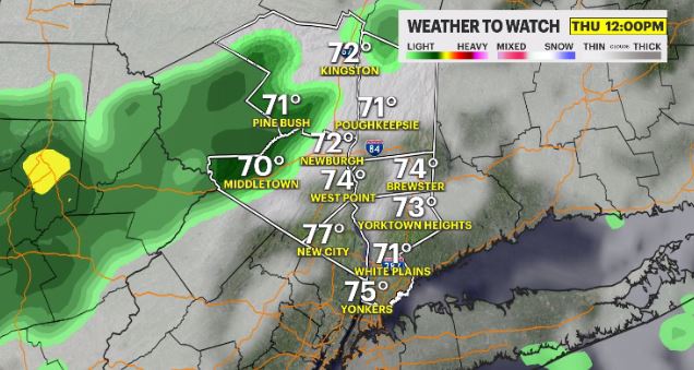
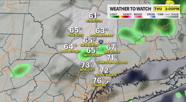
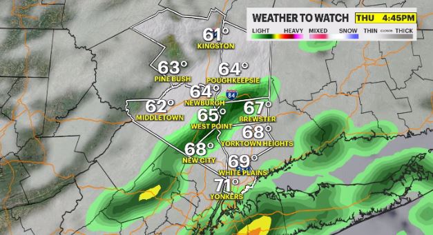
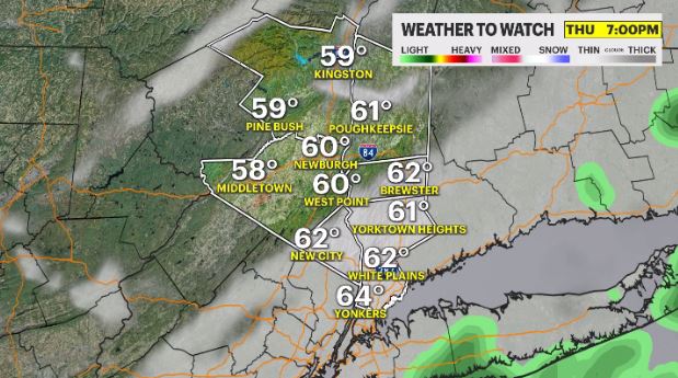
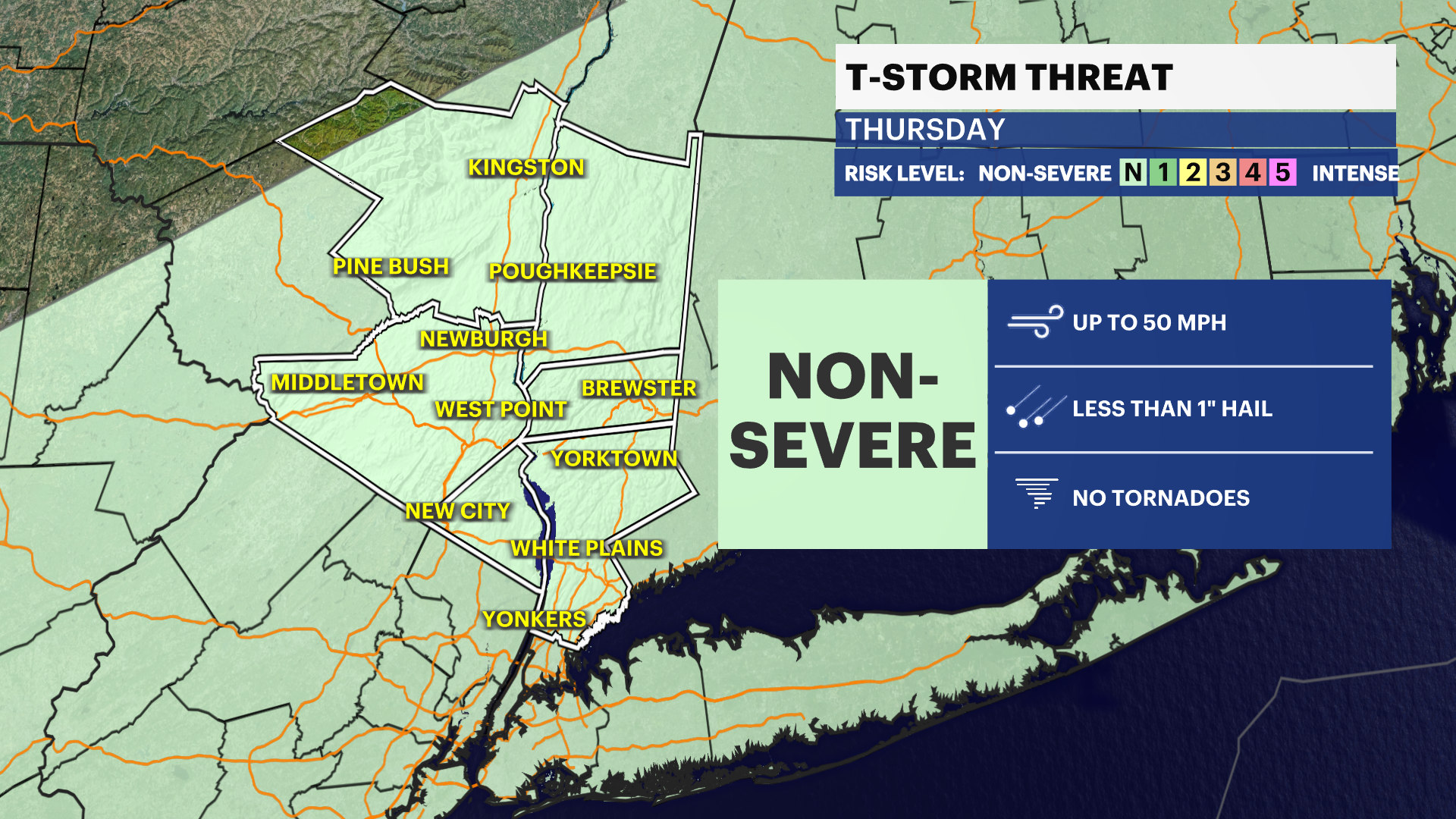
29ds agoWHAT'S NEW: A cold front approaches Thursday afternoon, kicking off the potential for some thunderstorm activity. Some of the storms could be strong to severe, with the main threat being gusty winds. The timing of the storms is mainly from 12 p.m. – 6 p.m.
WHAT'S NEXT: Pleasant weather arrives for the weekend and next week will see temperatures rising.
Storm Watch Team Meteorologist Addison Green says a warm spring day lies ahead with a threat of thunderstorms.
FORECAST:
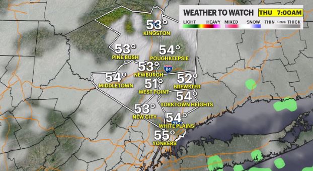
OVERNIGHT: Mainly cloudy, feeling damp and muggy as temps slowly rise past midnight. Areas of patchy to dense fog will be around overnight and early Thursday morning, along with isolated showers. Lows in the upper-40s to low-50s.
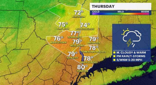
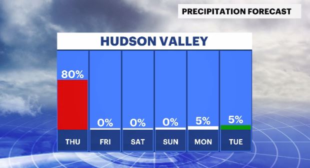
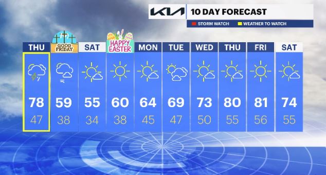
THURSDAY - WEATHER TO WATCH: Partly to mostly cloudy skies with a rain and storm chance in the evening and very mild temps. Some storms could produce gusty winds. Highs in the 70s. Lows in the 40s.
FRIDAY - GOOD FRIDAY: Mainly sunny, drier and breezy winds. Highs in the 50s to low-60s. Lows in the upper-30s.
SATURDAY: A few passing clouds. Highs in the 50s. Lows in the 30s.
SUNDAY - EASTER: Lots of sunshine and pleasant. Highs in the upper-50s to low-60s. Lows in the 40s.
MONDAY: Mostly sunny skies. Highs in the 60s. Lows in the 40s.
TUESDAY: Mix of sun and clouds. Highs in the 60s. Lows in the 40s.
WEDNESDAY: A few passing clouds. Highs in the upper-60s to low-70s. Lows in the upper-40s to low-50s.
THURSDAY: Mostly sunny. Highs upper-70s to low-80s. Lows 50s.
FRIDAY: Sunny skies and very warm temps. Highs in the 70s to 80s. Lows in the 50s.
SATURDAY: Mostly sunny and mild. Highs 70s. Lows in the 50s.
More from News 12
2:09

Emergency sewer repair project in Greenburgh stinks – but it’s necessary, officials say
2:05

Chilly morning, pleasant afternoon Sunday in the Hudson Valley
1:58

Residents learn more about $12.9M facelift proposal for Nanuet Public Library
0:48

Rain doesn't damper celebration at 13th annual Italian Feast and Festival in Tappan
0:53

Nearly $2 million to fund intelligence center, body cameras for Orange County law enforcement
2:00
