Temperatures to soar, could break record highs this week in the Hudson Valley
Storm Watch Team Meteorologist Addison Green says temperatures will soar, but the humidity will stay low.
Share:
More Stories
2:09

Saturn to be visible this weekend, with best viewing on Sunday
22h ago1:39

Why has hurricane season quieted down?
2ds ago
LIVE BLOG: News 12 weather updates
10ds ago1:04

Cooler temperature trend into start of meteorological fall
10ds ago1:34

Greenwood Lake leaders warn visitors to use common sense in the heat
10ds ago2:26

Heat & humidity strengthen, storm chances weaken, to bring a pleasant end to week
11ds ago2:09
Saturn to be visible this weekend, with best viewing on Sunday
22h ago1:39
Why has hurricane season quieted down?
2ds agoLIVE BLOG: News 12 weather updates
10ds ago1:04
Cooler temperature trend into start of meteorological fall
10ds ago1:34
Greenwood Lake leaders warn visitors to use common sense in the heat
10ds ago2:26
Heat & humidity strengthen, storm chances weaken, to bring a pleasant end to week
11ds agoWHAT'S NEW: Dry and very warm conditions through the rest of the work week. Morning lows and afternoon highs have a chance of setting new record highs.
WHAT'S NEXT: The chance for rain goes up for the weekend as the temperatures cool down. Those daytime highs will still be trending above the average high of 59.
Storm Watch Team Meteorologist Addison Green says temperatures will soar, but the humidity will stay low.
FORECAST:
OVERNIGHT: Mainly clear skies with less of a breeze. Temps will trend very warm, potentially setting a new record "warm low." Lows in the 50s.
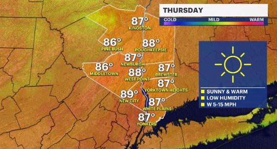
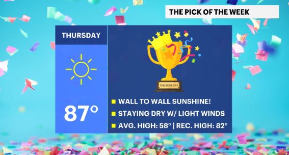
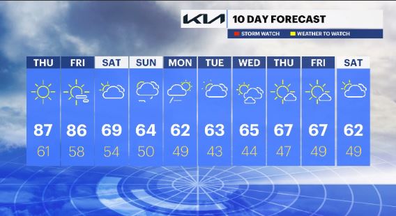
THURSDAY: Lots of sunshine and a light, dry breeze. The record high of 82 (1977) should be broken! Highs in the 80s. Lows in the upper-50s to low-60s.
FRIDAY: Mostly sunny skies with some scattered clouds later on as the warm temp trend continues. The record high of 78 (1968) should be broken! Highs in the 80s. Lows in the 50s.
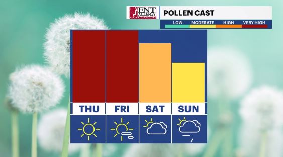
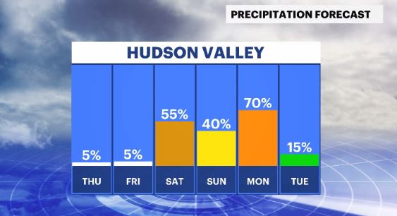
SATURDAY: Mostly cloudy with a chance for rain. Temps will still be running well above average. Highs in the upper-60s to low-70s. Lows in the 50s.
SUNDAY: Mostly cloudy with a chance for scattered showers, mainly in the late day. High in the 60s. Lows in the 40s.
MONDAY: Mostly cloudy skies at first with rain showers that will taper off through the day. Expect breezy winds as well. High in the 60s. Lows in the 40s.
TUESDAY: Partly cloudy with scattered rain showers. Highs in the 60s. Lows in the 40s.
WEDNESDAY: A mix of sun and clouds. Highs: mid-60s. Lows: mid-40s.
THURSDAY: Mostly sunny skies. Highs: upper-60s. Lows: upper-40s.
FRIDAY: Mostly sunny skies. Highs: upper-60s. Lows: upper-40s to low-50s.
SATURDAY: A mix of sun and clouds. Highs: low-60s. Lows: upper-40s to low-50s.
More from News 12
2:09

Emergency sewer repair project in Greenburgh stinks – but it’s necessary, officials say
1:57

Chilly morning, pleasant afternoon Sunday in the Hudson Valley
1:58

Residents learn more about $12.9M facelift proposal for Nanuet Public Library
0:48

Rain doesn't damper celebration at 13th annual Italian Feast and Festival in Tappan
0:53

Nearly $2 million to fund intelligence center, body cameras for Orange County law enforcement
2:00
