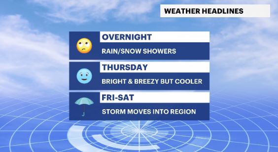
Overnight rain and snow showers ahead of cool, breezy Thursday in the Hudson Valley
Storm Watch Team Meteorologist Addison Green says temperatures will be cooler and winds will pick up on Thursday.
•
Mar 29, 2023, 10:13 AM
•
Updated 527 days ago
Share:
More Stories
0:48

Rain doesn't damper celebration at 13th annual Italian Feast and Festival in Tappan
53m ago1:58

Residents learn more about $12.9M facelift proposal for Nanuet Public Library
4h ago0:29

Police: 2 people shot in Newburgh
4h ago2:09

Emergency sewer repair project in Greenburgh stinks – but it’s necessary, officials say
5h ago0:26

Man charged with plotting shooting at a New York Jewish center on anniversary of Oct. 7 Hamas attack
10h ago2:07

Doctors urge men to get screened during Prostate Cancer Awareness Month
10h ago0:48
Rain doesn't damper celebration at 13th annual Italian Feast and Festival in Tappan
53m ago1:58
Residents learn more about $12.9M facelift proposal for Nanuet Public Library
4h ago0:29
Police: 2 people shot in Newburgh
4h ago2:09
Emergency sewer repair project in Greenburgh stinks – but it’s necessary, officials say
5h ago0:26
Man charged with plotting shooting at a New York Jewish center on anniversary of Oct. 7 Hamas attack
10h ago2:07
Doctors urge men to get screened during Prostate Cancer Awareness Month
10h agoWHAT'S NEW: As the cold front passes, rain and showers will come overnight into early tomorrow morning, but with little impact.
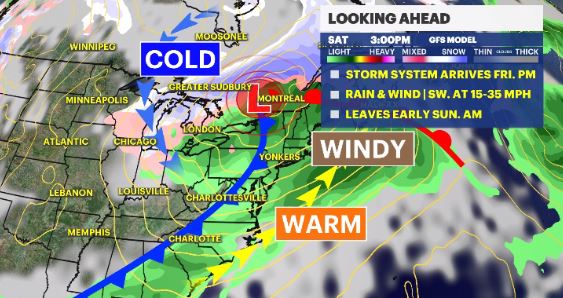
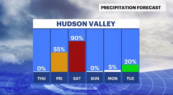
WHAT'S NEXT: Much like last weekend, the weekend ahead is a 50/50 split, with Saturday being wet and windy, and Sunday being breezy and drier.
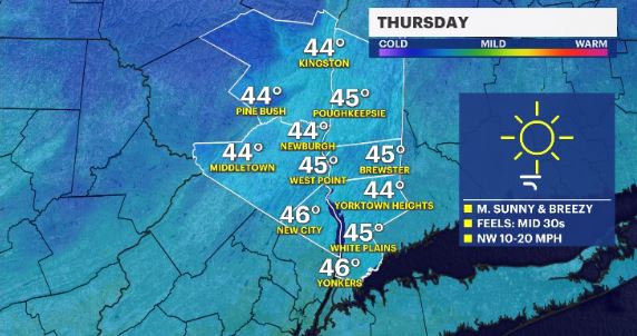
Storm Watch Team Meteorologist Addison Green says temperatures will be cooler and winds will pick up on Thursday. Bright and colder.
FORECAST:
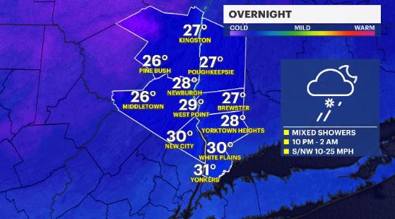
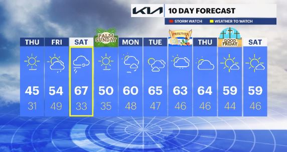
OVERNIGHT: A cold front brings a rain and snow shower chance overnight into early Thursday morning. Lows in the upper-20s to low-30s.
THURSDAY: Mostly sunny with a cool breeze. Highs in the mid-40s. Lows in the upper-20s to low-30s.
FRIDAY: Increasing cloud cover with a chance for rain late in the day. Highs in the 50s. Lows in the 40s.
SATURDAY - WEATHER TO WATCH: Rainy and windy throughout the entire day. Highs in the 60s. Lows in the 30s.
SUNDAY: Mostly sunny and windy at times. Highs in the upper-40s to low-50s. Lows in the 30s.
MONDAY: Partly cloudy and breezy in the morning. Highs in the upper-50s to 60. Lows in the upper-40s.
TUESDAY: Mix of sun and clouds with a milder feeling in the air. Highs in the 60s. Lows in the upper-40s.
WEDNESDAY - PASSOVER: Partly cloudy with scattered showers. Highs in the 60s. Lows in the mid-40s
THURSDAY: Partly cloudy. Highs in the 60s. Lows in the 40s.
FRIDAY - GOOD FRIDAY: Mostly sunny. Highs in the 50s. Lows in the 40s.
SATURDAY: Mostly sunny. Highs in the 50s. Lows in the 40s.
More from News 12
2:09
Emergency sewer repair project in Greenburgh stinks – but it’s necessary, officials say
2:05

Chilly morning, pleasant afternoon Sunday in the Hudson Valley
1:58
Residents learn more about $12.9M facelift proposal for Nanuet Public Library
0:48
Rain doesn't damper celebration at 13th annual Italian Feast and Festival in Tappan
0:53

Nearly $2 million to fund intelligence center, body cameras for Orange County law enforcement
2:00
