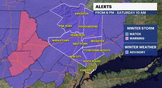
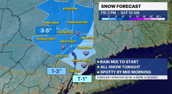
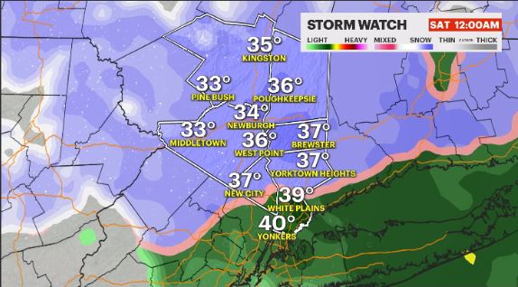
STORM WATCH: 1 to 5 inches of snow expected north of I-287 in the Hudson Valley
News 12 Storm Watch Team Meteorologist Addison Green says there could be 1 to 5 inches of overnight snow.
Share:
More Stories
2:09

Saturn to be visible this weekend, with best viewing on Sunday
yesterday1:39

Why has hurricane season quieted down?
2ds ago
LIVE BLOG: News 12 weather updates
10ds ago1:04

Cooler temperature trend into start of meteorological fall
10ds ago1:34

Greenwood Lake leaders warn visitors to use common sense in the heat
10ds ago2:26

Heat & humidity strengthen, storm chances weaken, to bring a pleasant end to week
11ds ago2:09
Saturn to be visible this weekend, with best viewing on Sunday
yesterday1:39
Why has hurricane season quieted down?
2ds agoLIVE BLOG: News 12 weather updates
10ds ago1:04
Cooler temperature trend into start of meteorological fall
10ds ago1:34
Greenwood Lake leaders warn visitors to use common sense in the heat
10ds ago2:26
Heat & humidity strengthen, storm chances weaken, to bring a pleasant end to week
11ds agoNews 12 Storm Watch Team Meteorologist Addison Green says there could be 1 to 5 inches of overnight snow.
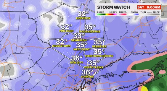
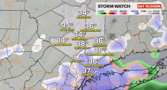
WHAT'S NEW: A slushy 1 to 5 inches of snow is likely for much of the Hudson Valley, especially north of I-287. Travel will be slick and icy overnight heading into Saturday. The storm pulls away by late Saturday morning.
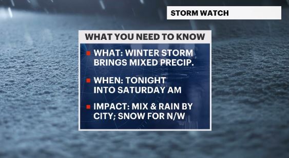
WHAT'S NEXT: The next storm to swing by could bring more rain and snow to the region Monday into Tuesday.
FORECAST:
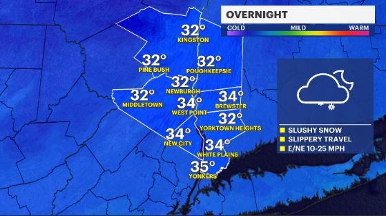
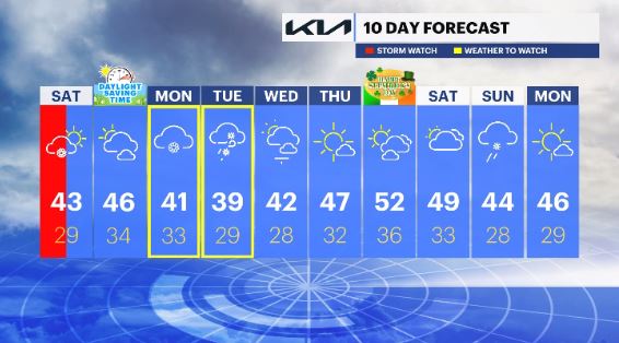
OVERNIGHT - STORM WATCH: Snow accumulates across much of the Hudson Valley. Expect slippery roads. Lows in the upper-20s to low-30s.
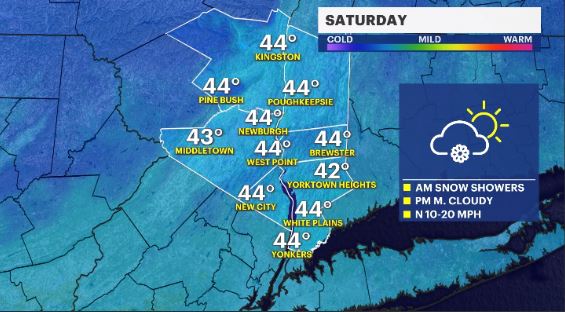
SATURDAY - STORM WATCH: Snow showers taper off in the morning with breezy winds and partly cloudy skies to follow. Highs in the upper-30s to low-40s. Lows in the upper-20s.
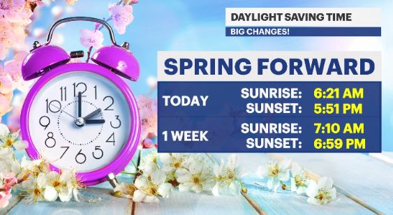
SUNDAY - DAYLIGHT SAVING TIME BEGINS: Mostly sunny to partly cloudy. Highs in the mid-40s. Lows in the mid-30s.
MONDAY - WEATHER TO WATCH: Cloudy with a chance of rain and snow. Highs in the upper-30s to low-40s. Lows in the low-30s.
TUESDAY - WEATHER TO WATCH: Snow showers at first then partly cloudy skies and windy conditions. Highs in the upper-30s to low-40s. Lows in the mid-20s.
WEDNESDAY: Sun and clouds with windy conditions at times. Highs in the upper-30s to low-40s. Lows in the upper-20s.
THURSDAY: Mostly cloudy and seasonable. Highs in the mid-40s. Lows in the upper-20s to low-30s.
FRIDAY - ST. PATRICK’S DAY: Sun and clouds with mild temps. Highs in the upper-40s to low-50s. Lows in the mid-30s.
SATURDAY: A mix of sun and clouds with a chance for rain showers. Highs in the upper-40s to low-50s. Lows in the low-30s.
SUNDAY: Cloudy with a mixed shower chance. Highs in the mid-40s. Lows in the upper-20s.
MONDAY: Mostly sunny and pleasant. Highs in the mid-40s. Lows in the upper-20s.
More from News 12
2:09

Emergency sewer repair project in Greenburgh stinks – but it’s necessary, officials say
2:05

Chilly morning, pleasant afternoon Sunday in the Hudson Valley
1:58

Residents learn more about $12.9M facelift proposal for Nanuet Public Library
0:48

Rain doesn't damper celebration at 13th annual Italian Feast and Festival in Tappan
0:53

Nearly $2 million to fund intelligence center, body cameras for Orange County law enforcement
2:00
