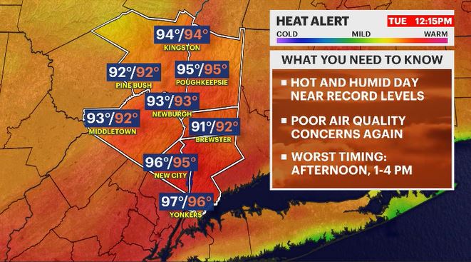
Heat Alert: it is a "Summer Sizzler" out today with a spotty afternoon storm
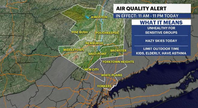
Air quality alerts and heat alerts are up for portions of the region
More Stories


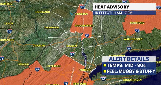
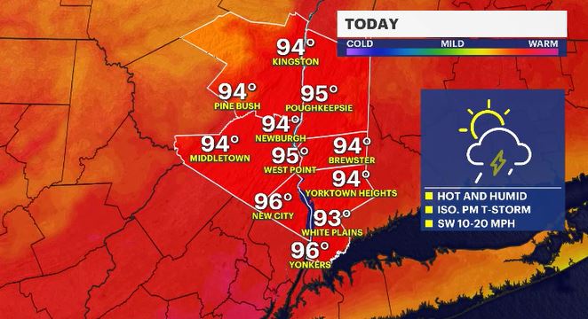
It is another day with a feeling around more typical for the middle of Summer as supposed to the middle of Spring. Temperatures will run about 10-25 degrees above average from the morning to the afternoon hours. Many spots will get into the mid-90s for daytime highs but will feel stuffy at times with an increased level of humidity. Feels-like temps will also be into the mid-90s. Take precaution if you are out and about during the afternoon hours. There are heat and air quality alerts in effect.
An Air Quality Alert is in effect for Rockland and Westchester Counties from 11 a.m. until 11 p.m. at the latest. It is due to elevated ozone levels. This is a typical Summer-like issue where high pressure is overhead, and the air is barely moving. The air at the surface becomes more saturated with pollutants from vehicles, buildings, and various other outlets. Without the wind to move things around, the air sits at the surface and becomes a concern for those with breathing issues & heart-health concerns. It is advised to not do any strenuous activity during the day, especially during the afternoon hours when daytime heating peaks.
Temperatures may continue to challenge daytime high records over the next several days. Here are the current records in White Plains, where weather data records are kept for the Hudson Valley
WHITE PLAINS
Sunday - 91 (1974) - we hit 87
Monday - 87 (2017) - forecast high: 84
Tuesday - 95 (1962) - forecast high: 95
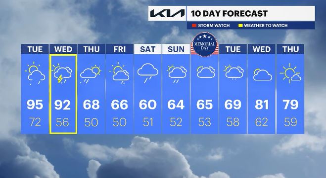
Wednesday - 95 (1996) - forecast high: 92
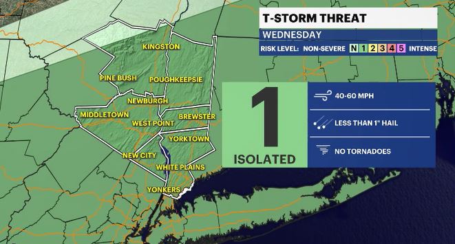
There will be a threat of a pop-up shower or storm this afternoon. Most locations will stay dry, but tomorrow is a different story. A cold front will approach the region, producing a potential line of showers and storms for the afternoon hours. Some of those storms could be strong to severe. Any severe storm could bring damaging gusts and small hail. We'll dry things out after Thursday morning with temperatures cooling down.
Memorial Day weekend does not look to be the greatest for the "unofficial start of Summer." Temps will be cool with scattered shower chances. Saturday could be the worst day of this upcoming holiday stretch.
ALMANAC:
Average High: 70 | Average Low: 51
Record High: 95 (1962) | Record Low: 37 (2009)
Sunrise: 5:33 a.m. | Sunset: 8:10 p.m.
THE FORECAST:
TODAY: HEAT ALERT - Hot and humid with temperatures challenging record highs. An isolated afternoon storm is possible. Highs: mid-90s.
TONIGHT: Partly cloudy, warm and stuffy. Lows: upper 60s to mid-70s.
WEDNESDAY: WEATHER TO WATCH - Hot and feeling humid. There is a chance for showers and storms in the afternoon with some potentially severe. Highs: low 90s. Lows: mid-50s.
THURSDAY: Showers fade early in the morning with a mix of sun and clouds to follow along with cooler temps. Highs: upper 60s. Lows: upper 40s to low 50s.
FRIDAY: Mostly sunny to mostly cloudy with a late day shower chance. Highs: mid-60s. Lows: upper 40s to low 50s.