Cool and mainly dry start to the week before soaking rain returns midweek to the Hudson Valley
Temperatures stay below normal through Tuesday before a wetter weather pattern brings rounds of rain and possible thunderstorms Wednesday into Thursday.
More Stories


FORECAST:
SUNDAY NIGHT - MONDAY:
Any rain will end overnight under mostly cloudy skies across the Hudson Valley. Cool temperatures will settle into the region overnight, leading to a cloudy and chilly start to Monday morning.
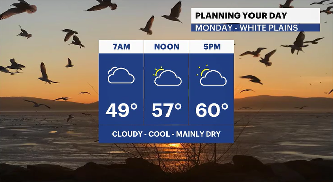
MONDAY:
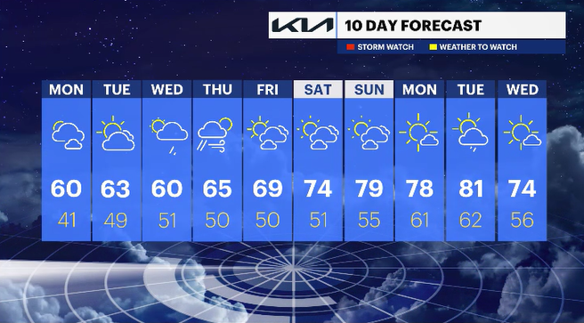
Temperatures Monday afternoon will struggle to move much beyond the upper 50s and low 60s for much of the Lower Hudson Valley. While the day is expected to stay mainly dry overall, there remains the chance for a few isolated showers later in the evening. Many neighborhoods, however, are likely to remain dry through the day.
TUESDAY:
Drier weather returns in full Tuesday with an abundance of sunshine expected across the region. Temperatures will also rebound slightly, climbing back into the mid-60s during the afternoon.
Clouds begin increasing Tuesday night ahead of the next storm system, setting the stage for a wetter stretch of weather during the middle of the week.
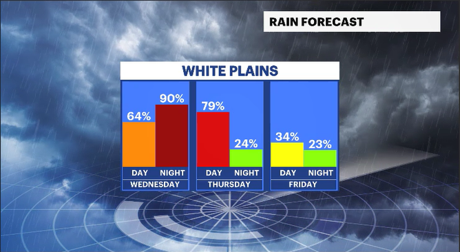
WEDNESDAY - THURSDAY:
Rain is expected to arrive by Wednesday morning and continue at times through Thursday. A few thunderstorms may mix in as well, but the primary concern at this time appears to be periods of steady rain and soggy conditions Wednesday into Thursday morning.
THE WEEKEND:
Looking ahead to next weekend, temperatures are expected to rebound into the 70s. Current indications suggest the weekend will remain mainly dry, but forecast details could still shift depending on how the midweek storm system evolves.
Stay with the News 12 Storm Watch Team for updates as it continue refining the forecast through the week.